Early to Mid Wisconsin // Mid Wisconsin to Pleniglacial // Full-glacial Wisconsin
For our region, the full-glacial Wisconsin environments (broadly construed) have the best Pleistocene data sets for vertebrate faunas and for vegetation as revealed in the woodrat midden record. On the basis of these as then recognized, life zones for the region were constructed (Harris 1985a, 1990a) and mapped (Harris 1990). As used here, a life zone is a biotic term indicating "broad commonality of plant and mammal taxa ... and does not imply coevolutionary relationships or long-term stability of the included biota" (Harris 1990a:220). Descriptions of the life zones are predominantly from Harris (1990a).
Because increasing latitude and increasing elevation decrease temperatures, elevations were standardized to "equator equivalents" (Harris 1990) by multiplying the latitude of a site by 107 (on the assumption that increasing elevation by 107 m decreases temperature by about the same amount as moving through 1° of latitude). The elevation of the site is added to this result to give the equator equivalent. As an example, a site at 35° N that is at an elevation of 1600 m would have an equator equivalent elevation (eee) of 5345 (35 X 1.7 + 1600).
 Northern Highland zone
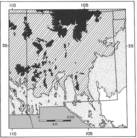
This zone was set up on the basis of western North American sites displaying full-glacial vegetational communities of tundra, boreal forest ("spruce-fir forest"), sagebrush, and grassland (Harris 1985a). In Fig. 1, this is shown as solid black. For this life zone, as for the others, the elevational boundaries are adjusted for latitude. In our region, this life zone was continuous in north-central New Mexico, but otherwise consisted of isolated highland areas. Tundra was present on high peaks and probably on exposed northern mountain slopes. Southern slopes and protected habitats supported boreal forest, though subalpine meadows and sagebrush grassland interrupted the forest.
Although there are a number of sites north of our region within this zone, our only cave site is SAM Cave at about 6700 m eee. Unfortunately, this is an Irvingtonian site.
Fig. 1. Map of New Mexico and adjacent regions showing the hypothesized distribution of full-glacial life zones. Black, Northern Highland Zone; hatched, Middle Elevation Savanna Zone; stippled, Sagebrush Steppe-woodland Zone; white, combined Steppe-woodland and Steppe zones. The regions south of the U.S. border (solid gray) has not been mapped. Adapted from Harris (1990).
Middle Elevation Savanna Zone
This zone differs from the Northern Highland Zone primarily in the loss of tundra elements and probably the absence of boreal forest in low-elevation areas possessing low relief. Thus most of the region mapped to this zone supported areas of boreal forest, sagebrush, and grassland (likely largely in the form of mixed sagebrush and grass). In southern New Mexico and much of Trans-Pecos Texas, woodland elements may have been mixed in below about 2000 m. The general conception is of scattered groves of trees with open expanses of sagebrush-grassland.
Sites within this life zone include Atlatl Cave, the Isleta Caves, Upper and Lower Sloth caves, Dust Cave, Howell's Ridge Cave, Muskox Cave, and Hermits Cave (Harris 1990a).
Sagebrush Steppe-woodland Zone
Boreal elements drop out at lower elevations, possibly excepting favorable microhabitats. Open woodland with grassy undergrowth and patches of sagebrush were typical.
A number of New Mexican sites fall within this zone, including the Blackwater Draw sites, Williams Cave, Burnet Cave, Shelter Cave, Conkling Cavern, the Dry Cave sites, Algerita Blossom Cave, and Dark Canyon Cave. Fowlkes Cave probably falls within this zone, though elevational data are not given by Dalquest and Stangl (1984b).
Steppe-woodland Zone and Steppe Zone
Few sites are available to aid in interpretation of these hypothesized zones. The Steppe-woodland zone is envisioned as similar to the Sagebrush Steppe-woodland Zone without the sagebrush element, while the Steppe Zone lacked woodland elements except in exceptionally favorable habitat. The zones are based on meager data from outside of our region and no informative sites occur within our region.
Literature. Harris 1985a, 1990a; Dalquest and Stangl 1984b.
Last Update: 1 Oct 2009